
Thermal Drone Services in Maine
Pet and Livestock Recovery, Property Inspections and Emergency Support
See what ordinary cameras can’t.
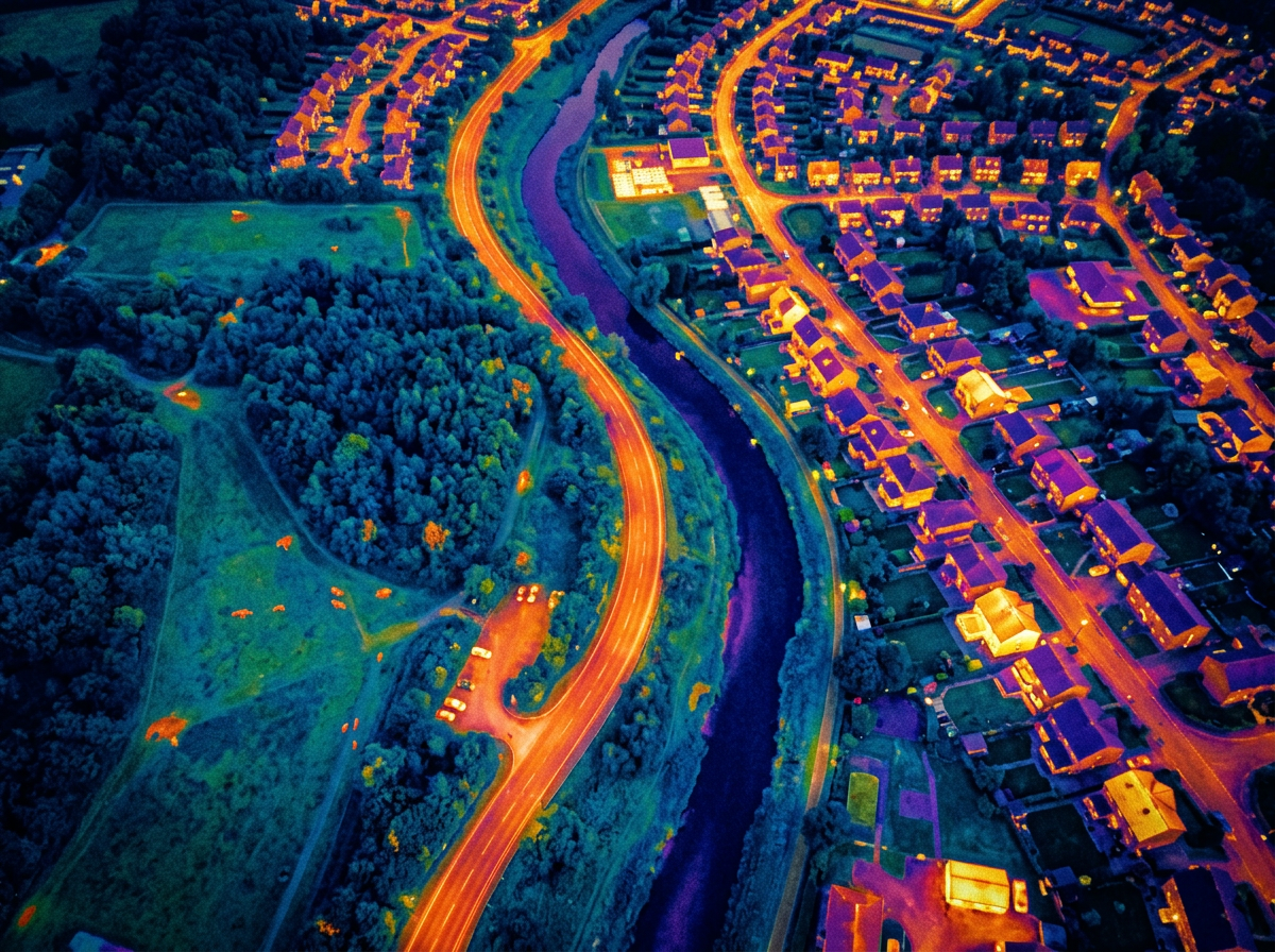
Billian Moments Productions provides professional thermal drone services throughout Western and Central Maine. Using advanced aerial thermal imaging, we can search large areas, identify heat patterns, inspect difficult-to-access structures, and provide valuable visual information from above.
Whether you are searching for a missing pet, checking livestock, evaluating a building, or requesting authorized emergency support, we provide safe, responsible, and professional aerial service.
Pet and Livestock Recovery
A Faster Way to Search Difficult Terrain
When a pet or farm animal disappears, searching fields, woods, and large rural properties on foot can take valuable time. A thermal drone provides an elevated view and may detect an animal’s heat signature when darkness, distance, vegetation, or terrain makes it difficult to see from the ground.
Thermal searches may assist in locating:
Lost dogs
Missing cats
Horses
Cattle
Goats
Sheep
Other domestic and farm animals
Early-morning, evening, and nighttime searches often provide the best thermal contrast between an animal and its surroundings.
What We Need From You
When requesting a search, please provide:
The animal’s last known location
The date and time it was last seen
A recent photograph
Its size, color, and identifying features
Its likely behavior around strangers
Its suspected direction of travel
Property-access information
Any sightings reported since it disappeared
Keep someone near the animal’s last known location whenever possible. Large, uncoordinated search groups may frighten the animal, push it farther away, and create additional heat signatures within the search area.
Thermal imaging can improve search coverage, but detection and recovery cannot be guaranteed. Results depend on weather, vegetation, terrain, access, temperature, airspace, and the animal’s location.
Emergency Thermal Drone Support
Aerial Awareness When Time and Visibility Matter
Thermal drones can provide valuable aerial information during certain emergency and time-sensitive situations. Billian Moments Productions may assist authorized agencies, organizations, property owners, and search teams with:
Missing-person search support
Large-property searches
Nighttime situational awareness
Difficult-terrain reconnaissance
Storm-damage documentation
Fire-scene observation
Post-incident aerial documentation
Location and observation of heat signatures
Emergency operations must be coordinated with the agency responsible for the incident. Billian Moments Productions does not independently deploy into active emergency scenes.
If someone is missing, injured, or in immediate danger, call 911 first.
Roof and Building Inspections
Identify Areas That May Require a Closer Look
Aerial thermal imaging can reveal temperature differences across roofs and building surfaces. These patterns may help identify areas associated with moisture intrusion, missing insulation, heat loss, air leakage, or other potential concerns.
Thermal building surveys are suitable for:
Commercial buildings
Churches
Schools
Apartment buildings
Warehouses
Residential properties
Flat and low-slope roofs
Agricultural buildings
Depending on the project, your deliverables may include thermal photographs, standard aerial images, marked areas of concern, and an organized digital report.
Thermal imaging identifies patterns and anomalies for further investigation. It does not replace an inspection or diagnosis by a qualified roofer, electrician, HVAC technician, engineer, or building professional.
Solar-Panel Inspections
Efficient Aerial Coverage of Solar Installations
Thermal imaging can survey solar arrays for unusual temperature patterns that may be associated with damaged, disconnected, shaded, or underperforming panels.
Solar inspection services may include:
Thermal overview of the installation
Standard high-resolution aerial photographs
Identification of visible heat anomalies
Thermal and visible-image comparisons
Marked images showing areas of concern
Organized digital delivery
Weather, sunlight, system operation, panel angle, and flight conditions can affect the results of a thermal solar survey.
Electrical and Infrastructure Surveys
Thermal drones can inspect elevated, remote, or difficult-to-access infrastructure while reducing unnecessary climbing and allowing large areas to be surveyed efficiently.
Potential applications include:
Electrical equipment
Utility infrastructure
Rooftop HVAC systems
Communications equipment
Industrial facilities
Construction sites
Agricultural facilities
Mechanical equipment
Our service documents observable thermal patterns from the air. Any electrical or mechanical findings should be reviewed by an appropriately qualified professional.
Advanced Aerial Thermal Technology
Billian Moments Productions operates the DJI Matrice 4T, an advanced commercial drone platform combining thermal imaging with high-resolution visible cameras, powerful zoom capabilities, low-light performance, and laser-assisted distance measurement.
This allows us to document a thermal observation while also capturing recognizable visual details of the same location.
Depending on your project, deliverables may include:
Thermal aerial photographs
High-resolution standard photographs
Thermal and visible-light comparisons
Annotated images
Aerial video
Location information
Written observation summaries
Custom project documentation
Every project is evaluated individually so the flight plan and final deliverables match the client’s actual needs.
Why Choose Billian Moments Productions?
Billian Moments Productions is based in Western Maine and understands the region’s rural properties, wooded terrain, changing weather, seasonal conditions, and challenging access.
Every thermal drone operation emphasizes:
Safe and responsible flight operations
Respect for private property
Respect for personal privacy
Clear communication
Professional aerial documentation
Practical results without exaggerated promises
Service tailored to the individual situation
All flights are subject to weather, airspace, property authorization, visibility, safety requirements, and applicable federal, state, and local regulations.
Service Area
Based near Farmington and Jay, Maine, Billian Moments Productions serves:
MAINE
NEW HAMPSHIRE
Travel outside the primary service area may be available depending on the location and scope of the project.
Frequently Asked Questions
When is thermal imaging most effective?
Pet and livestock searches are often most effective during cooler early-morning, evening, or nighttime conditions. Building and solar inspections require different environmental conditions depending on the purpose of the inspection.
Is finding a missing animal guaranteed?
No search method can guarantee detection or recovery. Thermal drones can cover large areas efficiently, but results are affected by terrain, vegetation, temperature, weather, animal movement, and access.
Can you search for wounded deer, bear, or moose?
No. Maine law prohibits using drones to assist in hunting deer, bear, or moose. Our animal-recovery services are limited to pets, livestock, and other legally permissible situations.
Do you provide official engineering or inspection reports?
We provide aerial thermal imagery and documentation of observable temperature patterns. Technical diagnoses should be made by the appropriate licensed or qualified professional.
Can you fly anywhere?
Not always. Every request must be reviewed for airspace restrictions, property access, weather, visibility, nearby hazards, and operational safety.
Request Thermal Drone Service
Tell us:
What needs to be searched or inspected
The location of the property
The approximate size of the area
When the service is needed
Whether the situation is urgent
What type of deliverables you need
We will review the location, airspace, weather, access, and project requirements before confirming the flight.
Missing Pet or Urgent Situation?
Call or text for the fastest response.
For inspections and scheduled projects:
Email: BILLIANMOMENTS@GMAIL.COM
Billian Moments Productions
Professional Thermal Drone, Aerial Imaging, Photography and Video Services